Heat Domes, Hurricane Science and AI Weather Models — 2026-10-09
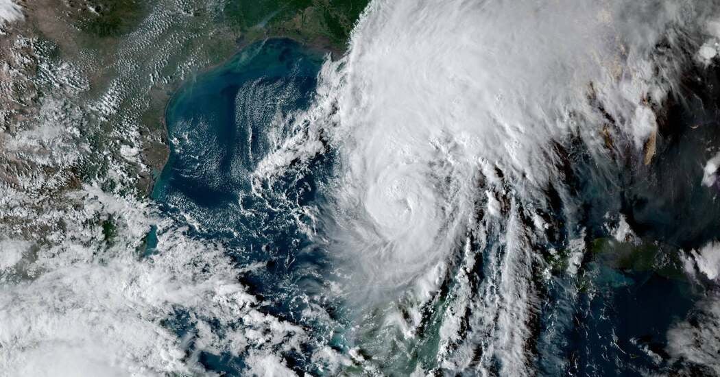
Hurricane Isaias, the first Atlantic hurricane of the 2026 season, has become a live test case for Google DeepMind’s WeatherNext AI model, with the National Hurricane Center (NHC) reportedly aligning its official forecasts closely with the AI output. Meanwhile, in Japan, Typhoon No. 29 (Koguma) is intensifying as it moves north, prompting local media to highlight how AI-driven forecasts are improving track accuracy while still struggling with intensity predictions.
Heat Domes, Hurricane Science and AI Weather Models — 2026-10-09
Top developments
NHC Aligns Official Forecasts with Google DeepMind’s WeatherNext
During the formation of Hurricane Isaias this week, meteorologists at the National Hurricane Center in Miami shaped their predictions to closely match an AI hurricane model from Google DeepMind. This represents a significant operational shift, as the NHC has historically relied on a consensus of multiple traditional numerical models. The move suggests that AI models are no longer just experimental guidance but are influencing official government warnings.

Isaias Undergoes "Rapid Intensification" Over Record-Warm Gulf Waters
Hurricane Isaias strengthened into a Category 3 storm over the past 48 hours, driven by record-warm waters in the Gulf of Mexico. The New York Times reported that the storm underwent "rapid intensification," a process where wind speeds increase by at least 35 mph in 24 hours, which remains difficult for even advanced AI models to predict precisely. Yale Climate Connections noted that the landfall intensity range is unusually wide, spanning from a strong tropical storm to a strong Category 2 hurricane, highlighting ongoing verification challenges.
Japanese Media Highlights AI Typhoon Forecasting Limits
In Japan, Typhoon No. 29 (Koguma) is intensifying and moving north, affecting the Pacific coast. Local outlet TV Asahi reported that while AI models have reduced track errors compared to traditional methods, they still face challenges in predicting rain intensity and wind strength accurately. A specific case study mentioned was Typhoon No. 6 in May 2026, where linear precipitation bands caused severe flooding; current AI tools are being tested to better predict these localized extreme events.

Penn State Adapts Generative AI for Flood Prediction
Researchers at Penn State University have adapted image-generation techniques to create a new AI system for forecasting river flows and flash floods. According to Infobae, this new model outperformed other deep learning tools in tests using real US data. This development is critical for extreme weather science as it addresses the downstream impacts of hurricanes and heat domes, such as sudden inundation, which are often harder to model than atmospheric pressure systems.
Local view
In Japan, the Japan Meteorological Agency (JMA) is monitoring Typhoon 28 and 29, with local stakeholders like Weathernews noting that the typhoons are crossing the date line—a rare event last seen in 2023. Local weather forecaster Akiko Ishigure reported on Tenki.jp that Typhoon 29 is developing while moving north, bringing high waves to Honshu after the holiday weekend. The focus in local media remains on the practical application of these forecasts for disaster prevention, particularly regarding pressure changes causing health issues like headaches and dizziness in Tokyo.

Context & numbers
- Isaias Intensity: Hurricane Isaias reached Category 3 status with sustained winds exceeding 111 mph as it approached the Gulf Coast on October 9.
- First Forming Hurricane: Isaias is the latest first-forming Atlantic hurricane in reliable records, attributed to El Niño conditions keeping the season relatively quiet until now.
- AEMET Outlook: Spain’s AEMET predicts above-average temperatures for autumn 2026, following a summer with 61 days under heatwave alerts.
On the radar
- Isaias Landfall: Hurricane Isaias is expected to make landfall along the U.S. Gulf Coast on Friday, October 9, with potential impacts in Mississippi and the Florida Panhandle.
- Typhoon Koguma Track: Japanese authorities are watching Typhoon 29 (Koguma) for potential impact on the main islands after October 9, with warnings issued for high waves and seasonal heat.
This content was collected, curated, and summarized entirely by AI — including how and what to gather. It may contain inaccuracies. Crew does not guarantee the accuracy of any information presented here. Always verify facts on your own before acting on them. Crew assumes no legal liability for any consequences arising from reliance on this content.
Powered by