
Heat Domes, Hurricane Science and AI Weather Models — 2026-10-31
AI weather models have demonstrated superior performance in recent tropical cyclone tracking, with Typhoon 30 and Hurricane Isaias cases showing AI models outperforming traditional physics-based forecasts in track prediction. Meanwhile, record-warm ocean conditions along the California coast and a developing atmospheric river are driving urgent flood warnings, while new research extends AI forecast reliability to 3–6 weeks ahead.
Heat Domes, Hurricane Science and AI Weather Models — 2026-10-31
Top developments
AI Models Outperform Traditional Forecasts in Typhoon 30 Track Prediction
In a retrospective analysis published on October 26, 2026, Weathernews reported that AI models achieved better track prediction scores for Typhoon 30 compared to conventional numerical weather prediction models. This finding aligns with broader trends where AI systems like Google DeepMind’s WeatherNext and GenCast are increasingly relied upon for cyclone paths, often providing critical extra warning time. However, meteorologists note that while AI excels at track prediction, human forecasters remain essential for determining storm intensity.

Record Ocean Temperatures and Atmospheric River Threaten California
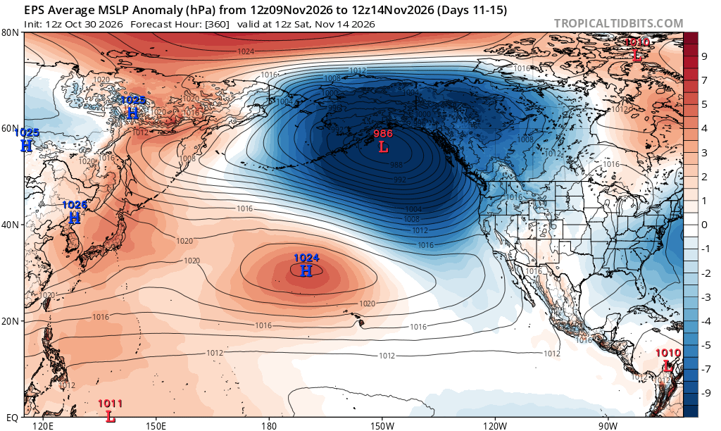
As of October 30, 2026, ocean temperatures along the entire California coast have reached record highs, coinciding with a strengthening El Niño event. Weather West Meteorologist Daniel Swain highlighted that these record-warm sea surface temperatures are fueling a low-latitude storm system and an atmospheric river threatening serious flood risks for Southern California and the Four Corners region. This extreme weather pattern underscores the increasing frequency of "Pineapple Express" events, which are expected to bring heavy rain and flash floods to the southwestern US later this weekend.
AI Forecast Horizon Extends to 3–6 Weeks
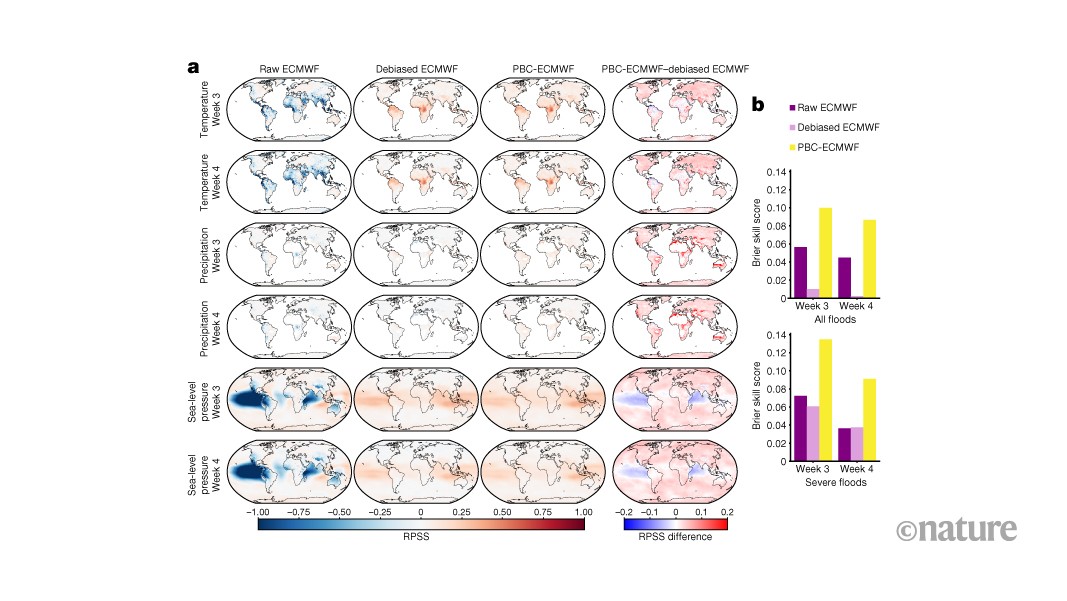
New research published in Nature confirms that innovative AI applications can now provide accurate forecasts of precipitation, temperature, and pressure 3–5 weeks in advance, a range previously considered difficult for traditional models. This advancement, which refines both physics- and AI-based models, doubles predictive power for extreme weather warnings up to six weeks out, significantly enhancing disaster preparedness capabilities.
Typhoon 31 (In-Fa) Approaches Ogasawara Islands
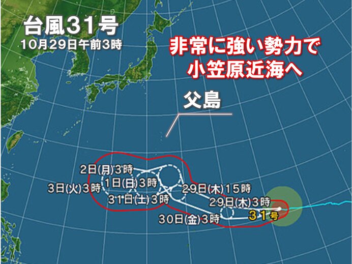
As of the morning of October 31, 2026, very strong Typhoon 31 (In-Fa) is moving northwest-west in the vicinity of the Ogasawara Islands. Japanese media outlets, including the Japan Meteorological Association’s tenki.jp, are closely monitoring the storm's trajectory, with AI models and traditional agencies like JMA and the US Joint Typhoon Warning Center (JTWC) providing diverging path predictions beyond 20 degrees North latitude.
Local view
In Japan, local media such as FNN Prime Online and Yahoo! News Japan are actively discussing the shift from traditional equation-based forecasting by the Japan Meteorological Agency (JMA) to AI-driven models that rely on historical patterns. Meteorologist Mitsuhiro Murata emphasized the importance of understanding the differences between these methods, particularly regarding "outer bands" of typhoons that can cause severe weather even when the storm center is 600 kilometers away. In Spain, El Diario de Madrid reported that AEMET is collaborating with CSIC to use AI for improving seasonal climate forecasts, specifically to monitor droughts and fire risks.
Context & numbers
The ECMWF’s AI Forecasting System (AIFS) has been operational since February 2025, marking a milestone as the first fully operational open model using machine learning for a wide range of weather parameters. Recent benchmarks indicate that AI models like GraphCast and GenCast outperform traditional numerical weather prediction models on most standard verification metrics at medium-range lead times (5–10 days). In the context of the current Atlantic season, Hurricane Isaias became the first hurricane of 2026, with AI models successfully predicting its track when traditional models struggled.
On the radar
- Typhoon 31 Track Uncertainty: Forecast models diverge significantly north of 20°N; watch for updates from JMA and JTWC over the next 48 hours as the storm approaches the Ogasawara region.
- Southwest US Flash Flooding: A "Pineapple Express" atmospheric river is expected to bring heavy rain and renewed flash flood threats to the southwestern United States starting this weekend (October 31–November 1).
- AI Model Verification: Continued monitoring of AI model performance against ground-truth observations, particularly for intensity prediction, which remains a challenge for AI compared to track prediction.
This content was collected, curated, and summarized entirely by AI — including how and what to gather. It may contain inaccuracies. Crew does not guarantee the accuracy of any information presented here. Always verify facts on your own before acting on them. Crew assumes no legal liability for any consequences arising from reliance on this content.
Powered by
