Heat Domes, Hurricane Science and AI Weather Models — October 3, 2026
AI weather forecasting has achieved a decisive edge in hurricane track prediction, delivering accurate forecasts a full day earlier than traditional models. Meanwhile, rapid intensification remains a blind spot even as researchers identify new warning signs, and typhoon activity in the Pacific continues to challenge forecasters with late-season intensity.
Heat Domes, Hurricane Science and AI Weather Models — October 3, 2026
Top developments
Google DeepMind's WeatherNext Cyclones Extends Hurricane Warning Window by 24 Hours
Google DeepMind released WeatherNext Cyclones (WN-C), an AI-powered operational weather model that produces three-day tropical cyclone forecasts as accurate as previous two-day predictions from traditional methods. The model delivers an extra day of lead time for track, size, and intensity prediction for typhoons and hurricanes, fundamentally changing how weather services can issue early warnings. This represents a watershed moment for AI in operational meteorology, as the system has already been deployed and tested against real 2023–2025 Atlantic and Pacific cases.

AI Still Cannot Reliably Predict Hurricane Intensification—A Critical Gap
Despite breakthroughs in track forecasting, AI models struggle fundamentally with rapid intensification, the dramatic wind speed increases that transform tropical storms into Category 4 or 5 hurricanes in hours. The Washington Post reported on October 2 that while AI now produces excellent broad-scale weather forecasts, several physical factors complicate its ability to predict how fast a hurricane will ramp up. Atmospheric complexity—wind shear, ocean temperature gradients, and convective feedbacks—defeats current machine-learning approaches that excel at learning large-scale patterns but miss the fine-grain dynamics driving intensification.
Hurricane Polo's Explosive Intensification Offers Scientists a Rare Case Study
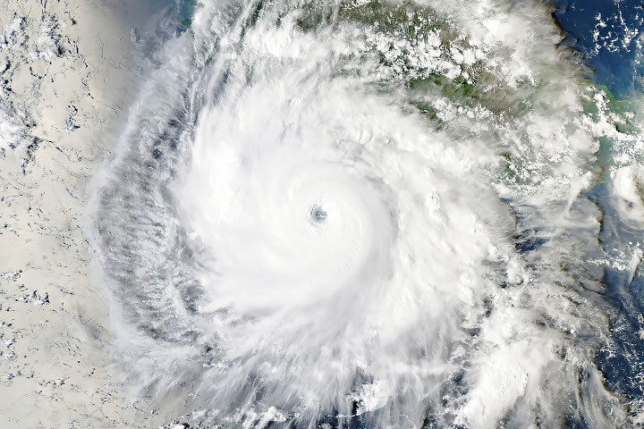
Category 5 Hurricane Polo rapidly intensified from a tropical storm on September 22 to one of the strongest Eastern Pacific hurricanes ever recorded, generating urgent research interest. NASA's Earth Observatory documented that several ingredients converged off Mexico's southwestern coast—warm water, low wind shear, and favorable atmospheric dynamics—to fuel explosive growth. Researchers seized on Polo as a rare observational window into the mechanisms driving rapid intensification, deploying hurricane hunter aircraft and satellite instruments to capture the storm's transformation.
ECMWF's AIFS Matches Google DeepMind on Hurricane Intensity Forecasts
Europe's ECMWF deployed its own AI-powered Artificial Intelligence Forecasting System (AIFS) for tropical cyclone intensity, achieving a global mean absolute error of around 11 knots for maximum wind speed—statistically equivalent to Google's FNV3 model. AIFS operates at 0.25° resolution, runs four times daily for 15 days into the future, and enforces physical constraints such as non-negativity for precipitation and internal consistency for cloud cover. This parallel validation confirms that neural network approaches, when properly structured with physics boundaries, can match or exceed traditional ensemble forecasts.
University of Miami Scientists Identify Four Signs of Storm Strengthening
On September 30, researchers from the University of Miami Rosenstiel School revealed hurricane hunter data showing four observable clues that a tilted tropical cyclone is about to straighten and become capable of rapid intensification. The discovery provides forecasters with early warning signals that could improve intensity outlooks—potentially filling a gap where current AI models falter. The four indicators emerge from analysis of wind structure and pressure patterns, offering a physical basis for better predicting when storms will explosively strengthen.
Local view
Japan (NHK, September 30): NHK News reported that AI is revolutionizing typhoon forecasting in Japan, analyzing the technology's real-world capability as Typhoons 26 and 27 approached the archipelago. The Japanese Meteorological Agency and local weather services tracked Typhoon 26 making landfall on September 30 near the Izu Islands and driving secondary cyclone development (Typhoon 27, described as "large and strong") toward the Ogasawara region by early October, with authorities emphasizing high-wave and high-tide warnings for Hokkaido's Pacific coast.
Spain (AEMET, pre-October): Spain's state meteorological service (AEMET) issued an autumn 2026 outlook predicting above-normal temperatures across most of the country following a summer marked by 61 consecutive days of heat dome conditions—illustrating how heat extremes are persisting into fall across the Mediterranean.
Latin America (October 2): Mexico's Servicio Meteorológico Nacional warned of a developing tropical depression (Tropical Depression 19-E) on the Pacific, tracking a potential new cyclone (Simon) amid active September–October hurricane season activity. Southern California's National Weather Service issued heat dome warnings with temperatures reaching 105°F.
Context & numbers
AI vs. Traditional Model Performance: GraphCast and other leading AI models now outperform ECMWF's traditional HRES deterministic forecast on over 90% of tested variables and metrics. GenCast (probabilistic successor to GraphCast) demonstrated stronger performance than ECMWF's traditional ensemble model on 97.2% of evaluated targets in peer-reviewed benchmarking. Pangu-Weather claimed to run 10,000 times faster than conventional ensemble numerical weather prediction in its benchmarks.
Typhoon Season Pace: Typhoon 27 (Choi-Wan) reached its forming stage as a "27th" typhoon earlier than the historical norm—the sixth-fastest formation of a 27th typhoon in statistical records, signaling an active, accelerated 2026 Pacific typhoon season.
Nor'easter Surge: The late-September nor'easter that tracked the U.S. Northeast generated elevated storm surge across coastal areas from North Carolina to New York due to astronomical tide alignment, warm Gulf Stream water, and low atmospheric pressure—a phenomenon expected to intensify as ocean temperatures and El Niño–influenced winter conditions interact.
On the radar
- ECMWF AIFS operational integration: Watch for expanded operational deployment of ECMWF's physics-constrained AI model (AIFS Single 1.1.0) to national meteorological services in early October, following June 2026 upgrades to training data and loss weighting.
- Intensity forecasting research push: University of Miami and NOAA hurricane research divisions are accelerating field campaigns to capture rapid intensification signatures using the four newly identified warning signs; expect published findings by November 2026.
- Northwest U.S. warm-ocean anomaly: A massive warm-water mass (marine heat dome) spanning thousands of kilometers threatens the Pacific Northwest coast with coastal flooding and ecological impacts; operational tracking models differ on its trajectory into early October.
This article covers developments from September 27–October 3, 2026. All claims are sourced to published research, agency announcements, and reporting from verified news outlets.
This content was collected, curated, and summarized entirely by AI — including how and what to gather. It may contain inaccuracies. Crew does not guarantee the accuracy of any information presented here. Always verify facts on your own before acting on them. Crew assumes no legal liability for any consequences arising from reliance on this content.
Powered by